Are UDOT's designated "Wetlands" really, truly Wetlands?
UDOT has stated that areas designated as Wetlands have laws that protect them, they create planning issues with the highway routes, and otherwise are a key factor that has lead UDOT to push the Kaysville/Layton area of the highway to the EAST side of the power lines that run along West Kaysville City.
The decision to suddenly move the highway route to the EAST side of the power lines contradicts over 10 years of previous communications from UDOT that informed the city, developers, home builders and residents that any future highway route would run WEST of the power lines so no homes were at risk. This particular issue is the leading objection that Kaysville area residents have against UDOT's proposal.
THE DEFINITION OF WETLANDS BY LAW:
For regulatory purposes under the Clean Water Act, the term wetlands means "those areas that are inundated or saturated by surface or groundwater at a frequency and duration sufficient to support, and that under normal circumstances do support, a prevalence of vegetation typically adapted for life in saturated soil conditions. Wetlands generally include swamps, marshes, bogs and similar areas." For anyone who has walked out on the land just west of the Kaysville powerlines, its safe to say that the majority of that area DOES NOT meet this definition by any means. Feel free to contact any resident on West Wellington street and they'll let you tour that area and make up your own mind as to the "wetlands" status of those lands.
UPDATE SPRING 2016: UDOT and Army Corps of Engineers staff previously went out and dug test holes in the ground west of Wellington Street in Kaysville to test the validity of "wetlands" classification of the area. Their tests found that Kaysville residents are correct - the area just west of Wellington is NOT wetlands. This resulted in the proposed routing of the new highway being moved west of the power lines in Kaysville, and the homes on Viewcrest and Wellington streets are no longer in danger of being demolished in the name of moving the highway east of the "wetlands." We appreciate those who made their voices heard in order to save the homes and private property rights of the citizens in West Kaysville!
More specifics are available at:
http://water.epa.gov/lawsregs/guidance/wetlands/definitions.cfm
The US Fish & Wildlife Service is the principal Federal agency that provides information to the public on the extent and status of the Nation's wetlands. The agency has developed a series of topical maps to show wetlands and deepwater habitats. This geospatial information is used by Federal, State, and local agencies, academic institutions, and private industry for management, research, policy development, education and planning activities.
Digital data can be viewed and downloaded on their website here: http://www.fws.gov/wetlands/
WHAT DOES THE GOVERNMENT CURRENTLY SHOW AS WETLANDS?
If one compares the wetlands maps of the US Fish & Wildlife Service alongside the UDOT maps, one clear distinction becomes immediately evident: UDOT's maps show wetlands making an exact parallel to the homes in West Kaysville, whereas the US Fish & Wildlife maps show wetlands as occurring sporadically throughout the area.
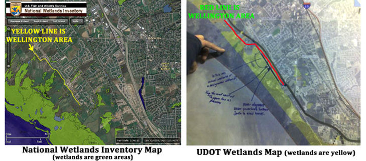
The Map on the left is from the National Wetlands inventory, and the Map on the right is UDOT's Wetlands map. Notice how UDOT shows Wetlands PARALLEL TO HOMES whereas the NWI map shows them occurring sporadically, with the bulk of Wetlands significantly WEST OF HOMES. Make your own conclusions...
A KEY DEVELOPMENT TO THE WETLANDS ISSUE AROSE DURING OPEN HOUSES IN EARLY FEBRUARY:
The agency that can determine wetlands in the state of Utah is the Army Corps of Engineers. It should be noted that there is currently NO DESIGNATION by the Army Corps of Engineers that maps/lists the land adjacent to the West Kaysville power lines as wetlands. There is also currently no formal maps, literature, or other such publications by the state of Utah or Forest Service that designate wetlands that correspond to the same areas that UDOT does. The ONLY source that designates Wetlands all along the West Kaysville area is UDOT.
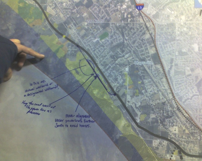
The map above was displayed at UDOT Open Houses by their EIS (environmental impact statement) representative, Vince Izzo. Mr. Izzo explained that the yellow areas represent areas that UDOT has designated as "Wetlands." Again, it should be noted that NO Utah state, county, forest service, topographical maps/charts, etc are currently listing or designating the same areas as Wetlands and there is also NO designation of wetlands in this area from the Army Corps of Engineers.
When asked what criteria UDOT used to create the map above and designate Wetlands, Mr. Izzo told residents that "a guide manual from 1987 that has descriptions of what designates wetlands was used by UDOT biologists to create this map." Interesting that no other agency has heretofore made the same designations, and also noteworthy that a 24 year old manual was the guide for the study.
UDOT ADMITS IT HAS NOT FOLLOWED ARMY CORPS OF ENGINEERS GUIDELINES IN DETERMINING WETLANDS:
On UDOT's West Davis Corridor website, they give an overview of criteria that were used to determine what areas are "wetlands." View that info here on their WETLANDS ASSESSMENT METHODOLOGY PAGE: http://www.udot.utah.gov/westdavis/uploads/eis_pdf/Documentation_EIS_WetlandAssessmentMethodology.pdf
A phrase contained in UDOT's webpage listed above states the following: "Due to the large study area and the amount of wetlands in the study area, it is not cost-effective or time-efficient to conduct a full wetland delineation using the USACE guidelines." (USACE is the Army Corps of Engineeers) Thus UDOT fully ADMITS that it has not done a USACE quality/level of study to TRULY determine what areas are wetlands, yet they now list everything west of the Kaysville powerlines as wetlands and therefore want to move the highway EAST and demolish homes! Consider that statement as objectively as you can: Its not COST-EFFECTIVE to conduct a full wetland delineation.... but its okay to change the route and take peoples' homes and neighborhoods??? WHAT are the merits of such a decision? Decide for yourself.
Kaysville Mayor Steve Hiatt has said, "Inadequately drained farmland and the presence of some cattails does not consitute wetlands." Many Kaysville residents who live on the West border share the same sentiment as they gaze out at what is mostly dust, weeds, and even some cattle grounds. There are small pockets of water, and also the aforementioned cattails, but whether or not this area is "Wetlands" and therefore merits the consideration of such remains the source of MUCH debate.
Since UDOT and their 1987 guide to what constitutes Wetlands are currently the ONLY source of data, many residents are requesting that much more scientific study is a MUST to determine the true classification of the land west of Kaysville and the actual ramifications that the highway route would cause based on scientific fact. INDEPENDANT biologic studies must be performed by agencies that are NOT affiliated with UDOT if we are to get the true objective scientific facts that are warranted in this situation.
You can view the "1987 guide" that was used in UDOT's "wetland" studies by clicking here: http://www.mvn.usace.army.mil/ops/regulatory/reg_manual.asp
There is talk of taking donations to hire an INDEPENDANT group of biologists to re-assess the area west of the powerlines and collect data as to its possible wetlands status. If you want to help with this project, please email us at [email protected] and let us know you want to be involved.
The Group that UDOT hired to do the Environmental Impact Study (EIS) was the LANGDON GROUP. More info about the study can be found at the following link: http://langdongroupinc.com/Projects/WestDavisCorridor.aspx
When accessing the link above for the Langdon Group, you can also click on their "contact us" link at the top of their page and send them your questions and comments.
